Hier sind
Bilder der letzten aufgezeichneten Überflüge Standort Dessau Süd. |
Nächste Satellitenüberflüge über Dessau, Deutschland
| Satellit
|
Start des Überflugs
|
verfügbare Zeit
|
Richtung
|
Max.
Elev.
(Ost oder West)
|
Frequenz
MHz
|
| UTC
|
Lokalzeit*
|
UTC
|
Lokalzeit*
|
| NOAA 15 |
22 Aug 05:56 |
22 Aug 07:56 |
22 Aug 06:02 |
22 Aug 08:02 |
southbound |
30° E |
137.62 |
| NOAA 15 |
22 Aug 07:35 |
22 Aug 09:35 |
22 Aug 07:43 |
22 Aug 09:43 |
southbound |
48° W |
137.62 |
| NOAA 15 |
22 Aug 17:20 |
22 Aug 19:20 |
22 Aug 17:29 |
22 Aug 19:29 |
northbound |
77° E |
137.62 |
| NOAA 15 |
23 Aug 07:09 |
23 Aug 09:09 |
23 Aug 07:17 |
23 Aug 09:17 |
southbound |
76° W |
137.62 |
| NOAA 15 |
23 Aug 16:54 |
23 Aug 18:54 |
23 Aug 17:02 |
23 Aug 19:02 |
northbound |
49° E |
137.62 |
| NOAA 15 |
23 Aug 18:35 |
23 Aug 20:35 |
23 Aug 18:41 |
23 Aug 20:41 |
northbound |
30° W |
137.62 |
| NOAA 15 |
24 Aug 06:43 |
24 Aug 08:43 |
24 Aug 06:51 |
24 Aug 08:51 |
southbound |
70° E |
137.62 |
| NOAA 15 |
24 Aug 16:29 |
24 Aug 18:29 |
24 Aug 16:36 |
24 Aug 18:36 |
northbound |
33° E |
137.62 |
* Lokale Zeit ist Mitteleuropäische Sommerzeit |
|
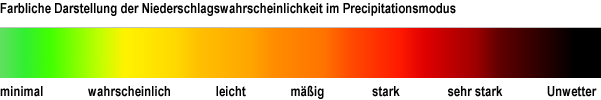
Die Satellitenbilder werden u. a. im Precipitationsmodus dargestellt. Hierbei werden hohe kalte Wolken eingefärbt, um ungefähr die Wahrscheinlichkeit und Stärke von Niederschlägen anzuzeigen.
Je dunkler die Einfärbung, je stärker der mögliche Niederschlag, also eine Art “Regenradar”.


